


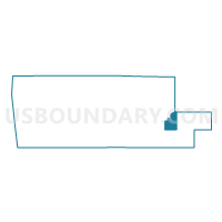
Voting District 1212508000002, Muskegon County, Michigan
About
Outline

Summary
| Unique Area Identifier | 598452 |
| Name | Voting District 1212508000002 |
| County | Muskegon County |
| State | Michigan |
| Area (square miles) | 18.30 |
| Land Area (square miles) | 16.30 |
| Water Area (square miles) | 2.00 |
| % of Land Area | 89.07 |
| % of Water Area | 10.93 |
| Latitude of the Internal Point | 43.24231840 |
| Longtitude of the Internal Point | -86.06162240 |
Maps

Graphs
Select a template below for downloading or customizing gragh for Voting District 1212508000002, Muskegon County, Michigan


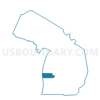
Neighbors
Neighoring Voting District (by Name) Neighboring Voting District on the Map
- Voting District 1211410000001, Muskegon County, MI
- Voting District 1212508000001, Muskegon County, MI
- Voting District 1212508000003, Muskegon County, MI
- Voting District 1215544000001, Muskegon County, MI
- Voting District 1216730000001, Muskegon County, MI
- Voting District 1217710000001, Muskegon County, MI
- Voting District 1231050000001, Newaygo County, MI
Top 10 Neighboring County Subdivision (by Population) Neighboring County Subdivision on the Map
- Egelston township, Muskegon County, MI (9,909)
- Cedar Creek township, Muskegon County, MI (3,186)
- Ravenna township, Muskegon County, MI (2,905)
- Sullivan township, Muskegon County, MI (2,441)
- Bridgeton township, Newaygo County, MI (2,141)
- Moorland township, Muskegon County, MI (1,575)
Top 10 Neighboring Place (by Population) Neighboring Place on the Map
Top 10 Neighboring Unified School District (by Population) Neighboring Unified School District on the Map
- Fruitport Community Schools, MI (17,961)
- Oakridge Public Schools, MI (9,950)
- Ravenna Public Schools, MI (6,093)
Top 10 Neighboring State Legislative District Lower Chamber (by Population) Neighboring State Legislative District Lower Chamber on the Map
Top 10 Neighboring State Legislative District Upper Chamber (by Population) Neighboring State Legislative District Upper Chamber on the Map
Top 10 Neighboring 111th Congressional District (by Population) Neighboring 111th Congressional District on the Map
Top 10 Neighboring Census Tract (by Population) Neighboring Census Tract on the Map
- Census Tract 29, Muskegon County, MI (5,346)
- Census Tract 32, Muskegon County, MI (5,168)
- Census Tract 33, Muskegon County, MI (5,095)
- Census Tract 9712, Newaygo County, MI (4,817)
- Census Tract 31, Muskegon County, MI (4,747)
- Census Tract 30, Muskegon County, MI (4,380)